
Castle Rock and Deliverance Cove.
The Lighthouse in its full glory on a glorious (rare) day.
Castlepoint is on the notorious coastline that runs from Cape Palliser in the south to Napier in the north.
It is located about 150km north of the cape and is an area rich in history.
It provided one of the few safe anchorages for the small coastal vessels the pioneers used.

This was one of the few calm days of the year.
The sea on the ocean side of the point was still a seething mass of foam.
This fisherman was one of several trying their luck.
Note the height up from the water.
Every thing is on quite a large scale for such a little spot on the map.
The climb up to the lighthouse is steep in places but is made easier because it is up a newly laid concrete path.

Interestly, the lighthouse is not built on the highest point of the reef.
The track continues up a wooden walkway and steps to a viewing platform.
It was a very clear day with views down to Flat Point in the south and up to Cape Turnagain in the north.
All of this coastline was first charted and named by Captain Cook - but more on this subject later.


There was two choices of where to stay.
A motorcamp next to the beach (expensive) or this new listing in our club book , the pub at Whakataki , just a few km inland and there was no camp fee ," just come in for a beer and perhaps a meal" they said.
We did both.
It is the only pub remaining of the many that traded back in the hayday of pioneer settlement.
It is delightfully old but well presented , only slightly modenised and reeks of days gone by and of the souls of people past.
The dining room , tables tasterly
covered with plastic tablecloths.
An old upright piano with a stack pf sheet music waiting for someones fingers to bring it to life.

Two boars heads and a well horned goat from the local hills share space with a trophy ( just two years old) for a seafood "catch and cook" (say it quickly and it sounds like Captain Cook) compedition.
Crayfish and paua cooked on a campfire.

Two of the first white settlers were the Reverend William Williams (his parents must have had a sense of humour) and William Colenso.
I am interested in this.
Up at Houhora Heads the original homestead was built by a Subrixky and Colenso , William ?
must check.

It , like so many others , was destroyed by fire and rebuilt several times in the last 100 years.
Some of the bach's in the little township date back to the early 1900's

A selection of newspaper clippings showing some of the historic moments of the past.
The central , lower photo is of an local Maori lady who died in 1951.
Her birth certificate showed she was 116 years old. She lived alone and tendered her garden until her death.
She was a patron of the pub every day.
A bottle of Waitemata beer was her choice and occasionally she would endulge in 2 bottles.

The Barmaid with a big friendly smile made us welcome.
The bartop is an ancient slab of kauri.
Pit saws , one man and two men models along with the files for sharpening them are displayed above along with photos of large fish , big hauls of fish and strings of ducks after a local shoot.

The most sought after catch on this coast is Crayfish , big crayfish.
It is hard to appreciate the size of these beasts with nothing to compare them with.
The one on the left is HUGE , my hand would not go around the tail at its smallest part , just above the tail fins.
It was a brave person who grabbed this one.

A short article on the long life of Ihipara Patuwai the 116 year old Maori lady mentioned above.
She wore a black silk dress every day and her mind was still sharp and clear.
She was 78 years old when the lighthouse was built.


Remember the photo of the fisherman on the reef and how high he was above the water?
Here is a clipping about two fishermen who were swept off the reef and drowned by a rouge wave.
Their bodies were never found.
While we were there we saw several waves crest over the top and cascade down into the lagoon.
Thankfully, not while I was talking to the fisherman.


Above is us set up in the camp behind the pub.
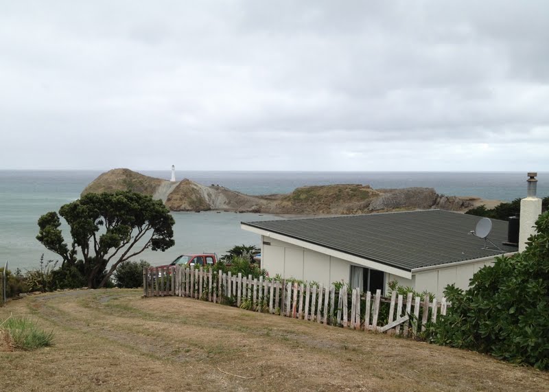
Castlepoint , clearly shows the higher headland.
Then we followed a road up the hill.
There was 20 or so bach's/homes up there , tied down to the rock.
We called it Stupidity Point.
It looks down onto the lighthouse.

Our timing was lucky enough to watch a crayboat being launched.
The normal weather makes it too rough to anchor or moor the boats.
They are launched and retrieved by a modified pea harvester.

They come in at speed , getting out between waves is the goal , not a problem today.
The boat is powered by twin Hamilton Jets and they are used to add their power to the rig which help provide a quick exit.

The boats are some 17metres long and the twin jet unit can be seen mounted the the Deep V of the hull.

The normal trailer boats are launched in the lagoon.
The dark patch on the reef in the centre of the photo is a wet patch caused by waves breaking over,
The white bit to the right is a wave cresting up.

From the walk up to the lighthouse, looking back to Castle Rock.
Named by Captain Cook because it reminded him of the English Castles and their fortifications


A Century of showing the way and still in use.
Many sailors said a Prayer of Thanks upon sighting the beacon.
Many years back , Captain Cook , Banks and the crew had been pounded by the relentless wind and waves that the Wairarapa coast has become known for.


He noted a break in the wave spray caused by the ocean rollers crashing onto the rocky foreshore and sent a longboat in to check out his suspicion that there was a inlet of some sort.
His brilliant seamanship proved him right , again.
They sailed in and set anchor for the first time in many days.
He named this haven - Deliverance Cove.
DoC have set up local history information displays , such as this one in many places in the area.

From the Castle Point viewing platform I took this telelense shot of our rig and the launching rig.

The reef is made up of many various rock formations.
Different colours and rock types , basalt rock overlaying limestone for instance.

The crayboat coming back in - note the wash caused by the Jet drives being powered up to assist the rig to exit the water and the diesel plume from the rigs motor loading up as it takes on the heavy load.
Another safe recovery.
Today was easy - they said.
 |
| Add caption |

Castle Rock stands at the Southern side of the entrance to Deliverance Cove.

From the viewing platform , looking south and down to our rig as shown in the telelense photo.
Deliverance Cove , the reef and Castle Rock in the background.

Three good examples of the various rock types that form the whole reef.


Balancing rocks and cantilevered rocks add variety to the landscape.
Another fisherman trying his luck from the reef.
Just behind him is a slightly lower section that the odd wave was crashing over despite the locals saying that this was a very calm day!

The highest section of the reef.
The knotch is massive - the dark spot on the right is a 4x4 vehicule and the tiny spot on the skyline above it is the fisherman in the photo above.

Just to the left of the 4x4 is this plague - a Memorian to lost fisherman and a warning to new fisherman.
Two more photos of Stupidity Point structures.


the lighthouse -


a trailer full of girls arriving for a Surfing lesson-
the entrance to Deliverance Cove -

the township viewed from Castle Point -

the rocks -

the reef and Deliverance Cove -

and Castle Point -
Great experience and the best of memories.
Farewell.